By Eric Dinerstein, PhD, Chief Scientist, Conservation X Labs
We are in the midst of a mass extinction of nature, the sixth in the history of life on Earth, and the first caused by human activities. Reversing the processes of extinction is also a human endeavor and a matter of utmost urgency, requiring ambitious, focused science-based conservation targets matched by renewed commitments to achieve them. The most well-known target is now referred to as “30 x 30”, shorthand for protecting 30% of Earth’s land and seas by the year 2030. This time bound goal was adopted by the Kunming-Montreal Global Biodiversity Framework in 2022, and more than 196 countries have now signed on to the pledge.
Currently, only about 17% of Earth’s terrestrial area and 12% of the marine realm are listed as protected, so much conservation work lies ahead to meet this deadline. The target, however, might be best seen as only a milestone, important as it is: many scientists present strong evidence that 30% is insufficient. They argue that protecting 50% of the Earth’s surface by 2050, if not sooner, is essential to prevent massive, irreversible biodiversity loss and to stabilize the climate, two interdependent goals. For now, however, 30 x 30 represents the best immediate chance as a down-payment to save life on Earth.
One of the main challenges to achieving 30 x 30 is that human resources and financial support are limited, even for the basic steps of safeguarding and monitoring already established conservation areas. Is the rapid expansion of protected area networks to prevent extinctions and safeguard nature even possible given budget shortfalls? Here is where the fourth industrial revolution—the Age of Artificial Intelligence, or AI—can play a major role in protecting and restoring wild nature globally. How might innovative AI-based conservation technologies, combined with keen biological insight, save time, effort, and money to make 30 x 30 achievable and enduring and restore a vibrant biosphere?

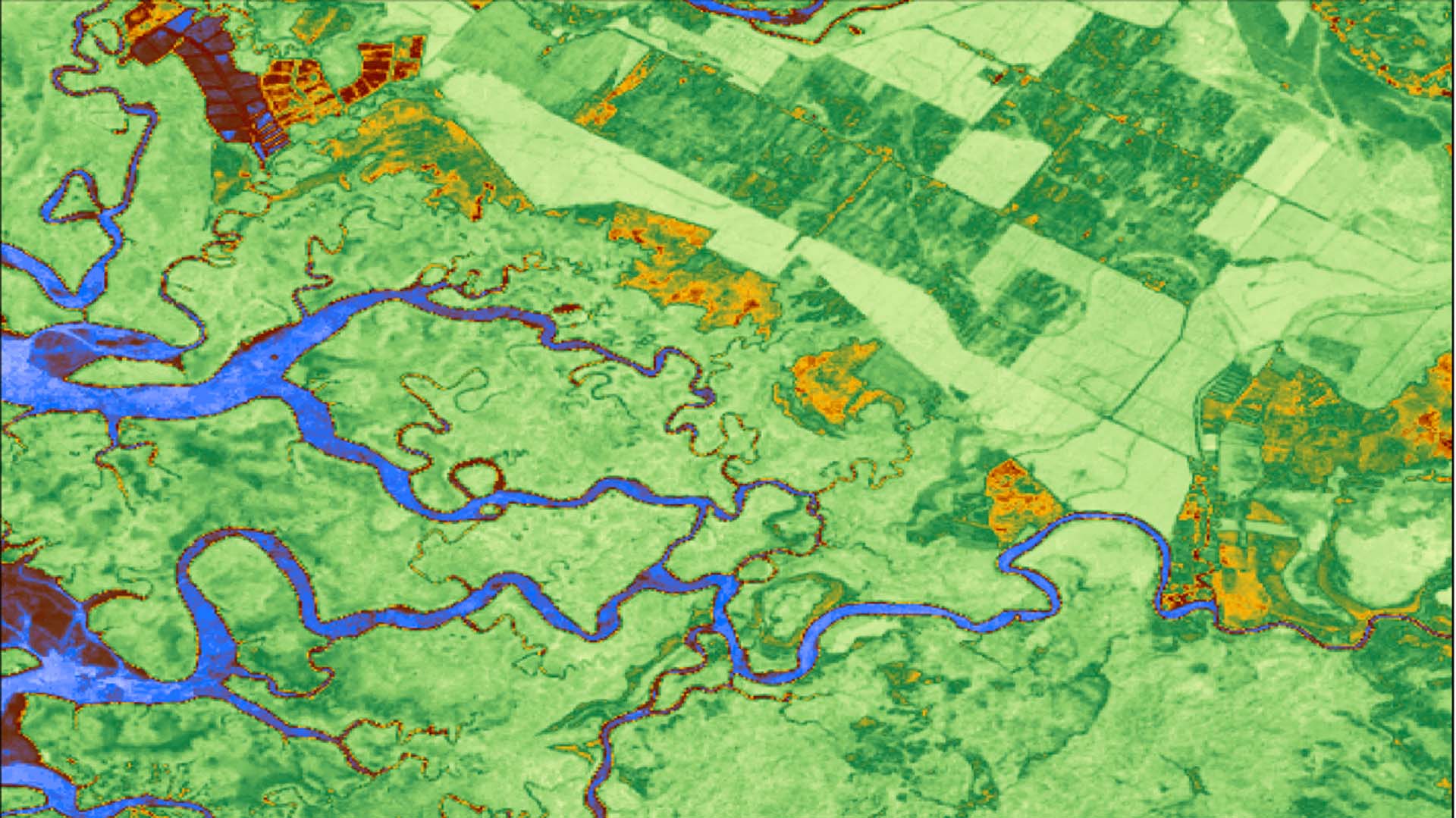
To evaluate progress towards the 30 x 30 milestone, simple spatial analysis using geographic information systems can map the amount of nominal additional area set aside each year. But such an easy-to-measure metric can mask serious science-based concerns. From a biodiversity perspective, quality is as important as quantity. Put simply, we could reach 30 x 30 by adding large reserves in, say, the boreal forests of Canada, in tundra, or the Sahara Desert and still fail to protect many of the world’s most biologically diverse spaces, such as relatively small terrestrial areas in the tropics that are the last refuges for many endangered narrow-range endemic species. A recent study showed that protecting only an additional 1.2% of the Earth’s terrestrial surface, including 0.65% of that terrestrial surface in the tropics, home to most of those endemic species, could address that particular gap in protection. That’s an example of keen biological observation without the need for AI. Where AI can assist human planners is by creating a vital data layer missing from our global tool kit—an accurate and dynamic land-cover map that reflects recent and ongoing changes in land use. The use of AI geospatial foundation models can efficiently convert satellite images into information, including land use and land cover. This advance is essential as currently there are no good global-scale land cover models available on an annual basis. This gap makes it difficult to both plan spatial targets under national biodiversity conservation plans and set targets globally under the Kunming-Montreal Global Biodiversity Framework, and monitor those targets accurately over time. Created with assistance of AI, this new land cover model will become part of the conservation road map underpinning 30 x 30.
AI can also enhance early warning systems and improve response to fires and deforestation, which pose significant threats to critical biomes like the Amazon. "Artificial Neural Network" models that combine satellite imaging technology with deep learning have shown promising results at detecting fire in remote areas earlier, complementing current large-scale monitoring systems and further improving our ability to effectively protect forests.
A far more vexing problem is the knowledge that many of the protected areas recently added, and even previously established reserves, exist only on paper with no real monitoring, protection, or enforcement due to their remoteness, limited budgets with which to carry out necessary tasks, or both. It is this aspect where innovative conservation technologies can play a massive role in successfully achieving 30 x 30.

Using new space-based sensors, scientists are able, for the first time, to monitor biodiversity from space, for example, by detecting the condition and health of coral reefs (e.g., mapping the extent of coral bleaching events or die-offs) or the intactness of the canopy layer of tropical rainforests, the Earth’s two most diverse ecological systems in the sea and on land. But what such satellite sensors cannot do in the terrestrial realm is to assess the state of wild nature underneath the canopy layer. Throughout the tropics, there is growing evidence of what’s been called “the empty forest syndrome,” a term used to describe where as best as we can tell from satellite imagery, the structure of a forest looks intact but the canopy and the forest underneath are devoid of vertebrate species, the wildlife having been hunted out by humans.
Now, however, where forests and grasslands have suffered from overharvesting or poaching of wildlife, new, ground-based sensors that are cheap, easy-to-use, and durable can make the protection of wildlife far more effective. AI-embedded sensors placed strategically on trails used by poachers have had a major impact on detecting intruders and transmitting real-time alerts over cellular networks, Long Range Radio (LoRa) or satellite to give park officials, for the first time, the situational awareness to stop poachers before they kill.
Let’s take, for example, the renowned Serengeti National Park in Tanzania. This reserve, at nearly 15,000 km2, about the size of the state of Maryland, is protected by a small staff of fewer than 200 rangers. Poaching was so intense a few years ago that it was estimated that more than 140,000 migratory wildebeest were estimated to have been caught in snares annually. And that’s just the wildebeest—giraffes, Cape buffalo, impala, and other ungulates also are poached for the industrial bushmeat market.
But what if tiny, energy-efficient, AI-powered camera-alert systems could send images of poachers detected by their on-board algorithms, in real time, to ranger teams to mount a rapid response? What if 95% of the human patrols in vast reserves like the Serengeti, assisted by new technologies, shift instead to what we might term “event-triggered rapid response”, where guards react to actual incursions? Instantly, the 200 rangers in the Serengeti become as effective as 2,000 rangers trying to patrol in a patterned way the same area.


This concept, where AI-embedded sensors running appropriate models can do the work of many human look-outs, is often described as a “force-multiplier.” Making use of the force-multiplier effect is essential as new parks are added around the world, especially in remote areas, to prevent threats like poaching from decimating the wildlife the park was created to protect.
The same force-multiplier effect using AI sensors could help address another serious threat to tropical forests: the illegal logging of high-value timber. In many tropical forests, a thriving black market persists for some incredibly valuable hardwoods—rosewoods, ebony, mahogany, and teak, to name a few well-known species. Not only do these tree species store the most carbon, they are also often the largest trees in a given forest, and they play critical roles in the ecological web. The activities of timber smugglers cost tropical countries millions of dollars in lost revenues each year. The same AI sensors that could detect poachers before they shoot wildlife or set snares could also detect loggers or empty logging trucks before the tree-cutters start their chainsaws and then alert forest protection staff. Becoming “eyes-on-the-forest”, these sensors could rapidly pay for themselves in preventing illegal felling of high-value trees. Keen conservation insights can tell us where these sensors could be placed for greatest effect.
AI sensors in the field have the ability to monitor endangered wildlife species in many new reserves created under 30 x 30. Soon, next-generation camera sensors combined with collaborative platforms for individual animal re-identification will provide biologists with the gold standard for wildlife monitoring—statistics on density and abundance—to allow us to track the population trajectories of selected species over time to determine if the wildlife management interventions being made are leading to recovery. This same approach could monitor use of critical habitats by wildlife or movement through the corridors that link reserves to maintain gene flow among populations of rare species. Computer scientists have increasingly accurate models that run in the camera and in the cloud to detect individuals of the most iconic species—elephants, rhinos, gorillas, chimpanzees, orangutans, tigers, jaguars, clouded leopards—species whose presence and abundance tell us a lot about the health of the ecosystems in which they occur.

Use of AI sensors is not just for one-way traffic, only focused on stopping poachers and loggers from entering protected areas. Another important application of AI is its use to address the most pressing wildlife management problem in Asia and Africa, and increasingly in other parts of the world: human-wildlife conflict. Human-wildlife conflict occurs when species such as elephants, tigers, lions, leopards, jaguars, or bears leave the reserves or occupy buffer areas and enter areas of human habitation. To be of use, AI models must be able to detect conflict-prone species and indicate their movements to alert guards and communities when such species come close to villages, livestock grazing areas, or croplands.
As an example, in India in 2023, elephants killed 605 people and tigers killed 116 people, with many more sustaining serious injuries and requiring financial compensation from the government. As wildlife populations recover in the reserves and connecting corridors that are part of 30 x 30, we need innovative technologies that allow for real-time detection of conflict-prone species and are integrated with deterrent technologies, to prevent situations from escalating. AI models can detect conflict-prone species and alert guards and communities before such species come close to villages, livestock grazing areas, or croplands. “Rewilding,” a global effort to restore biodiversity and build resilient ecosystems, requires co-existence, a goal many conservation biologists view as critical to restoring wild nature and the ecological interactions of species and their habitats.
Finally, a central tenet of the 30 x 30 project is to create new reserves in locations where extinctions are predicted to be most swift and severe. Along the equator, there are about 1,300 island archipelagos where plants and animals evolved in the absence of large herbivores or predators. When such non-native species invade, they often drive the fragile biota to extinction. Here, it’s not only unprotected islands that face the threat of invasives, but even in such iconic protected sites like the Galápagos Islands, or on many islands in the Caribbean, the arrival of cats, goats, rats, snakes, and the like spell potential doom for the native species that never evolved escape or defense mechanisms.
AI-embedded camera alert systems linked to satellites can provide biosecurity officers with vital information about the arrival of invasives on remote islands, or whether invasives have returned in numbers after eradication campaigns. Protecting island biotas from invasives and allowing endemic populations of plants and animals to recover is perhaps the best example of AI-based conservation technologies to restore wild nature. The cost savings from use of AI-embedded systems on tropical archipelagoes is immense and a centerpiece of the restoration program that lies ahead under 30 x 30.
Many other examples come to mind where new AI-based technologies now available or on the horizon can exponentially accelerate the protection of nature. All that we lack to make these electronic guardians of wild nature ubiquitous —and to make the dedicated heroic individuals on the front lines of conservation even more effective— is government support and a few philanthropic individuals who love nature and understand how the new AI-based technologies can be game-changers in ensuring the restoration of wild nature for future generations and the success of 30 x 30.